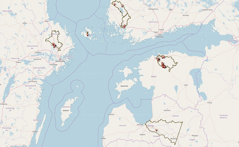
WaterChain pilot areas

Open interactive map in new window
River Eurajoki, Finland
Eurajoki is a 52-kilometer-long river in the southwestern Finland. It sources from lake Pyhäjärvi (in municipalities of Eura, Säkylä and Pöytyä) and flows through municipalities of Eura and Eurajoki into the Bothnian Sea. Its total catchment area is 1335 km², which includes also two main rivers, River Yläneenjoki and River Pyhäjoki, which both discharge into lake Pyhäjärvi. The largest tributary of River Eurajoki is River Köyliönjoki which originates from Lake Köyliönjärvi.
Nearly 80 % of the land in the pilot area is covered with agricultural land and forest. Small urban areas are located near Lake Pyhäjärvi and Lake Köyliönjärvi, and in the municipality of Eurajoki near the discharge point of River Eurajoki.
Nutrients:
The point sources include wastewater treatment plants, industry, peat production sites and a waste treatment plant. The loads originate mainly are from diffuse sources because of intensive agriculture and farming, peat soils, spreading manure into the fields, high P-value in field soil etc.
Hazardous substances:
Due to lack of data of hazardous substances, the possible point sources are estimated. When mapping possible point sources according to the field of activity and environmental permits 30 point sources were found in total, treated effluents from 2 wastewater treatment plants, 18 SMEs including a recycling center and paper mill as well as 3 leisure activity facilities and 7 gas stations.
The main possible sources of hazardous substances are storm waters containing hazardous substances incl. alkylphenols, phthalates, polybrominated diphenyl ethers (PBDE), agricultural activities (pesticides), and bisphenol A (BPA), which is used in a paper mill located at Eurajoki river area manufacturing thermal point of sale receipt paper. When used in thermal paper, BPA is present as free (i.e. discrete, non-polymerized) BPA, which is likely to be more available for exposure than BPA polymerized into a resin or plastic.
Examples of WaterChain activities:
Building a small-scale phosphorus filter
For our sea’s sake 2017 & 2018
Event organizers: How to take water and environmental protection into account?
River Aurajoki, Finland
Aurajoki is a 70-kilometer-long river in the southwestern Finland. It sources from the esker’s springs of lake Oripää and flows through the municipalities of Oripää, Pöytyä, Aura, Lieto, Kaarina and Turku. Aurajoki discharges into Archipelago Sea in Turku. Its total catchment area is 873.4 km². The catchment area includes the Aurajoki main stream and its tributaries, containing one midsize and three small rivers. There are in total 27 rapids within Aurajoki and its tributaries. There are two dammed reservoirs made for drinking water purposes. The catchment area includes only one lake, Savojärvi (1.1 km²) in the National park of Kurjenrahka in Pöytyä.
Most of the pilot area is covered by forests. Almost 40 % of the catchment area is in agricultural use. The pilot catchment area is rather sparsely inhabited. The biggest urban area is in the city of Turku with 189 000 residents. There’s no large heavy industry in the catchment area. However, there are some minor areas of small-scale industry.
Nutrients:
The municipal wastewater treatment plants previously operated within Aurajoki catchment area have been closed and waste waters are redirected to areal wastewater treatment plants. The effluent of areal wastewater treatment plant is in Archipelago Sea, Turku. The main source of nutrients is diffuse load from agriculture. In addition, waste waters from scattered housing, forestry and storm water contribute to the diffuse load.
Hazardous substances:
There is only one point source within Aurajoki catchment area that is listed in the national (VAHTI) register of point load sources. This point source is a metal coating company with one factory in Turku and one in Aura municipality. There is very limited research information available on diffuse load of hazardous substances in Aurajoki catchment area.
Examples of WaterChain activities:
Phosphorus precipitation at small hotspot ditch
Selecting the load reduction method for my field
Åland Water drinking water catchment area, Finland
The pilot area in Åland consists of three lakes: lake Dalkarby (0,167 km2), lake Långsjön (1,43 km2) and lake Markusbölefjärden (1,56 km2). Lake Dalkarby träsk is situated in the municipality of Jomala, Lake Långsjön in Jomala and Finström, and Markusbölefjärden in the municipality of Finström. The total catchment areas of these lakes are 3,62 km², 17,12 km², and 12,21 km2, respectively.
Lake Dalkarby has an inflow from a few ditches around the lake. The lake is surrounded by farmland, a small mountain and a small forest, as well as the Åland water waterworks, an athletics arena and small settlements. Lake Långsjön has an inflow through a couple of small lakes and several ditches around the lake. The lake is surrounded by farmland, forests and small settlements. Lake Markusbölefjärden has an inflow through several small lakes and several ditches around the lake. The lake is surrounded by farmland, forests and small settlements.
Nutrients:
No point sources are identified for any of the three lakes. However, the main source of nutrients is diffuse load from agriculture. In addition, waste waters from scattered housing, forestry, and storm water contribute to the diffuse load.
Hazardous substances:
No point sources are identified for any of the three lakes. The main possible sources of hazardous substances are agriculture, forestry, the athletics arena and small settlements.
Examples of WaterChain activities:
Waterworks: Clean drinking water for everyone
Event organizers: How to take water and environmental protection into account?
Tallinn drinking water catchment area, Estonia
The pilot area in the north Estonia consists of two main rivers: 105-kilometer-long River Pirita and 99-kilometer-long River Jägala. The largest municipalities in the area are Tallinn, Kose, Rae and Jõelähtme. The river Pirita sources from the Pususoo swamp and river Jägala from Pandivere upland. They both discharge to the Baltic Sea and are connected with the lake Ülemiste through manmade channels.
The total catchment area of the Tallinn watershed is about 2552 km², and it consists of three rivers (Pirita, Jägala and Soodla) that are connected through manmade canals and interlinking reservoirs. A small amount of water from the rivers in the catchment area is directed to Lake Ülemiste, where it is treated for drinking water purposes. Most of the water flows directly into the Baltic Sea.
One third of the area is covered with agricultural land along with forest and semi-natural areas (48 %). Most common soil type in the pilot area is sand-clay. Nearly a third of the area is covered by peat soils. There are many cattle farms in the pilot area and the estimated annual load from animals for nitrogen is 1225 tons per year and for phosphorus 360 tons per year. Nearly three per cent of the pilot area is urban with more than 50 000 inhabitants. The capital of Estonia, Tallinn, is situated near the pilot area with about 450 000 inhabitants. There are no large industries in the pilot area.
Nutrients:
The main point sources include wastewater treatment plants, peat production sites and quarries. The main source of nutrients (mainly nitrogen) is diffuse pollution from agricultural activities, forestry and peat soils. Annual average concentrations of phosphorus in the measurement points are lower than the state threshold.
Hazardous substances:
Due to lack of data of hazardous substances, the possible point sources are estimated. Mapping of possible point sources according to the field of activity and environmental licenses – 40 point sources: SMEs and 12 small wastewater treatment plants. The main possible sources of hazardous substances are storm waters (containing hazardous substances incl. alkylphenols, phthalates, PBDE) and agricultural activities (pesticides).
Examples of WaterChain activities:
Policy makers: Modelling of nutrient inflow to the Baltic Sea
Mapping of hazardous substances, passive sampling
River Daugava, Latvia
Daugava is a 1020-kilometer-long river that sources from the Valdai Hills in Russia and flows through four Latvian municipalities in its lower reaches: Ogre, Ikskile, Stopini and Salaspils. The river discharges into the Gulf of Riga.
The total catchment area is about 87 900 km², and it takes up a fourth of the territory of Latvia. Three large hydropower plant dams have been built on the river. In the lower reaches the catchment area includes a chain of lakes (Lielais Baltezers, Mazais Baltezers, Juglas, Kisezers) that are connected to the river via a network of interconnected channels. Several wastewater treatment plants are located in this area: Ādaži, Carnikava and Vangaži. These treatment plants discharge treated wastewater into the Gauja River, which then flows into the Baltic Sea. RTU’s pilot is located in Ādaži municipality wastewater treatment plant.
The catchment area in the lower reaches of river Daugava is used for agriculture (about 20 %) as well as forestry (about 20 %). Around 50 % of the catchment is urban areas – city of Riga, town Ogre and town Ikskile.
Nutrients:
The point sources include a wastewater treatment plant at lake Mazais Baltezers, some industry in the urban areas, as well as several pig or dairy farms. The diffuse loading comes from intensive agriculture and animal farming, as well as in the form of run-off from the urban areas.
Hazardous substances:
Due to lack of data of hazardous substances, the possible point sources cannot be estimated.
Examples of WaterChain activities:
Removal of nutrients in wastewater treatment plant
River Fyris, Sweden
Fyris is an 80-kilometer-long river in the southeast of Sweden. The river sources from the lake Rastsjön, and discharges into the lake Mälaren in Flottsund, Uppsala. As for Lake Mälaren, it later discharges into the Baltic Sea.
The total catchment area of river Fyris is about 2 000 km², and it covers parts of the municipalities of Knivsta, Tierp, Uppsala and Östhammar. River Fyris has several tributaries: Vattholmaån, Vendelån, Björklingeån, Jumkilsån and Sävjaån with its tributaries Funboån and Storån. The area is covered to 60 % by forest, 32 % by agriculture, 4 % by wetlands, 2 % by urban areas, and 2 % by lakes.
Nutrients:
There is discharge from one major and eleven smaller wastewater treatment plants with effluent standards of 0.3–0.5 mgP/L, and 10 mgN/L for the major treatment plant in Uppsala. There is also run-off-water from agriculture, urban storm water, atmospheric deposition of nitrogen, and on-site sewage treatment facilities in rural areas.
Hazardous substances:
Discharge from one major and eleven smaller wastewater treatment plants. Many industries are or have been in the river Fyris catchment area; pharmaceutical industry, food and beverage industry, mining and metal industry, brick industry and commodities industry. Perfluorinated alkylated substances (PFAS) have been used extensively in firefighting exercises at the airfield and are released in wastewater as one point source and also into the groundwater and river Fyris.
Examples of WaterChain activities:
Policy makers: Modelling of hazardous substances inflow to the Baltic Sea
Policy makers: Where to start when one wants to imply new regulations for WWTP representatives to include novel treatment technologies?

